
Hiking in Glacier: Surprising Struggle to Find Trailheads
The first thing you need to know is that there is NO internet connection in the park. So if you plan to use AllTrails, make sure you download it before you lose your internet connection. If you do get to West Glacier and find that you desperately need internet, go to Apgar Village on the West side and to St. Mary’s on the East side (if you need internet near Bowman’s Lake, good luck; go back to Whitefish, I guess).
You may be thinking, "Why does this matter?” Or “Of course there is no internet access in the park; usually, there isn’t internet in national parks.”
Planning a trip to Glacier, I knew not to expect internet in the park. I had downloaded several routes with AllTrails in advance. What I didn’t expect was to need extra assistance finding trailheads.
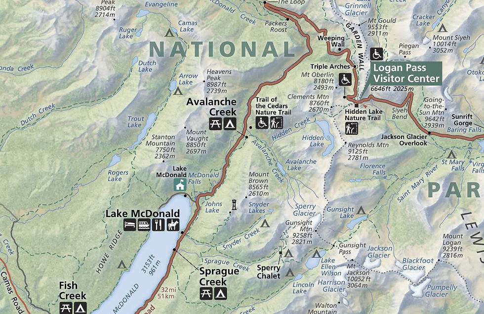
Usually, the maps for national parks, the ones you get for free when you enter, have some trails marked on them (see comparison images of Glacier NP Map and Big Bend NP Map). Additionally, when you are driving through the park, you will see signs for turnoffs for “such and such” trailhead.
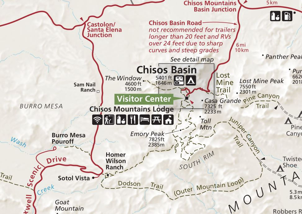
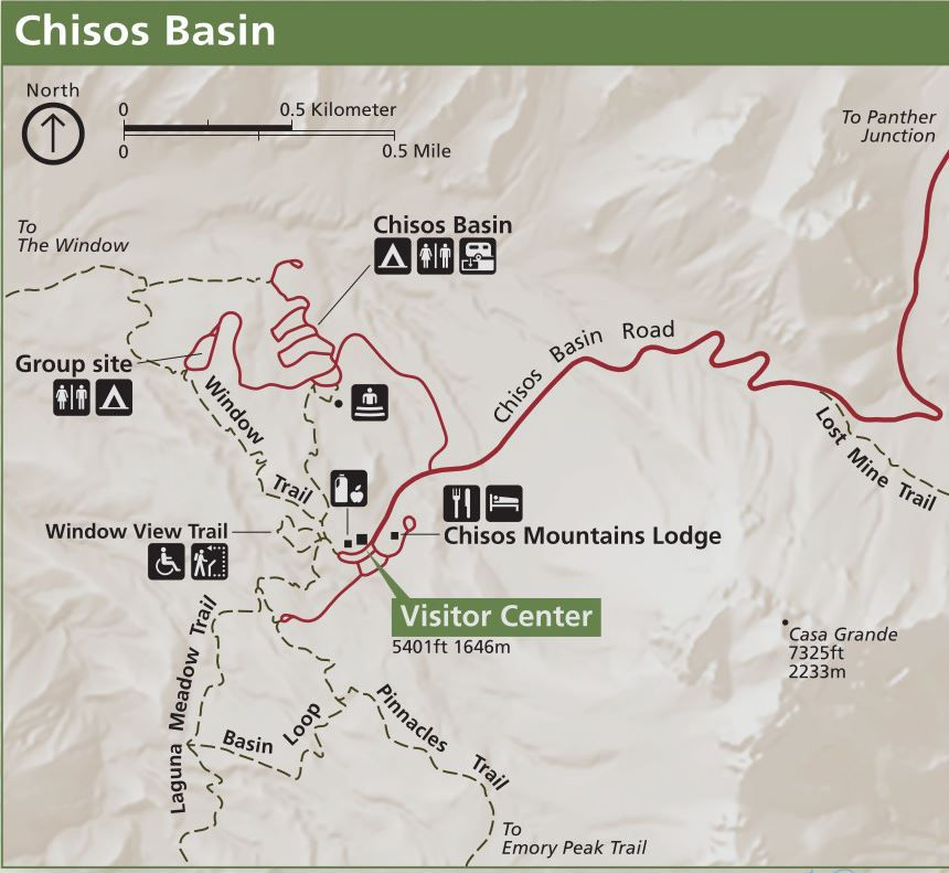
This is not the case in Glacier National Park. We spent two hours searching -driving, stopping to look around at different turnoffs and then driving again - for a trail that we never found. We eventually gave up and went on “Trail of the Cedars,” which was a very enjoyable hike and was also on our list of hikes to visit. The hike we were looking for was the McDonald Creek Trail to see the Sacred Dancing Cascade and McDonald Falls. There were signs for roadside viewing of these water features, but there were no signs for “such and such trailhead” or “ blank trailhead parking”. Trail of the Cedars is one of the trails that is very well marked with road signs, a parking lot, and directions to the trailhead, which was why it became our backup hike for the morning.
My Recommendation
After this struggle to find our hiking trail, we bought "Day Hikes of Glacier National Park Map Guide", by Jake Bramante ($14.95 on Amazon and the same price in the park at gift shops). There are several definite benefits to this map over the free map you get when you visit the park. On the “Day Hikes” Map, there is a definite emphasis on hiking trails throughout the park, including less-visited areas such as Two Medicine Lake, the many lakes on the Northwest side of the park, such as Bowman’s Lake, and backcountry trail routes (the map does end at the USA-Canadian border so it will not be helpful if you are doing a through-hike or visiting Waterton Lakes National Park in Canada).
On one side of the map is the actual map, complete with routes for individual hiking trails. The other side of the map is the “guide” portion which breaks up the different hikes by distance into the following categories: 0-5 miles (0-8 km) - 29 routes, 5-10 miles (8-16 km) - 23 routes , 10-15 miles (16-24 km) - 26 routes, and 15+ miles (24+ km) - 10 routes. The guide includes information on where to find the trailhead, notable sights along the way, elevation gain/loss, and total distance, making it a useful companion to AllTrails or a stand-alone resource.
We were happy to have this for the rest of our visit to the parks. I particularly liked that this is a nice, water-resistant map that can be used to find hikes and navigate to different areas of the park. We used it to navigate from West Glacier to Two Medicine and then to St. Mary’s, and from West Glacier to Bowman's Lake when our GPS couldn't work due to a weak signal. It was very reassuring to have a nice hard copy when we were heading into more rural areas on sparsely populated dirt roads, like those we needed to take to get to Bowman’s Lake.
An additional FREE option is printing off maps or downloading more detailed maps from NPMAPs.com before you go. This website has more focused maps of different areas of the park such as Lake McDonald trail map, Two Medicine trail map, North Fork trail map, St. Mary Falls inset map, and many more.
Missed Hike Resolution
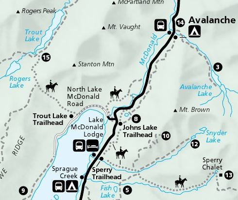
As for the hike we couldn’t find on the first day of our visit to Glacier National Park, using the “Day Hikes” Map, it is now apparent that we missed multiple opportunities to find the trail. You can park along Lake McDonald Road at the head of the trail, or you can park at Sacred Dancing Cascade near the other end of the trail. There are lookouts for both McDonald Falls and Sacred Dancing Cascade along the road, so we were still able to see them that day.
We were eventually able to complete part of the originally missed McDonald Creek Trail hike; however, we took a variant called John’s Lake Loop, which is 1.9 miles and passes both Sacred Dancing Cascade and McDonald Falls, as well as John's Lake. To find the John’s Lake Trailhead, turn down Lake McDonald Road, where there is abundant parking and a sign for John’s Lake along the side of the road.
Avalanche Lake Hiking Tip
Avalanche Lake is a very popular hike at Glacier National Park. We ran out of time on our trip and did not have the opportunity to do this hike. Because it is very popular, the parking area can be completely full (It was packed when we went there to try to hike, but we probably got there too late in the day, around 10AM). Based on my research, there is no drop-off option for the park shuttles or the red bus tours at this trailhead. In order to find a park at the trailhead during the busy season, you need to get there very early in the morning to beat the crowds, or risk waiting and driving around the parking lot for what will probably be an uncomfortable amount of time.
There is a trail - Avalanche Trail - that starts across the street from Lake McDonald Lodge. It runs parallel to the Going-to-the-Sun Road but is predominantly under tree cover where you do not see the road. This trail eventually joins up with the Avalanche Lake Trail.
HOT TIP: If you get to Avalanche Lake parking and it is full, don’t just give up on the hike; instead, consider extending your hike. Consider parking along the Lake McDonald Road or even at Lake McDonald Lodge. It will add 6.2 miles to your total trip if you leave from Lake McDonald Lodge (less if you leave the park on Lake McDonald Road), making it more of a day trip than a half-day trip. However, you can combine this with the John’s Lake Loop to shorten the hike. This isn’t necessarily an ideal solution, but I would have been happy to do it as a backup option.
Hope this helps! Happy adventures!

Comments